
Alaska geologic mapping by helicopter

Detailed Description
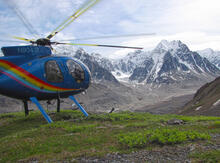
A helicopter waiting to pick up geologic mappers and move them to a new location in the western Alaska Range in south-central Alaska. Helicopters are an essential part of geologic fieldwork in the many remote, rugged regions of Alaska. In the western Alaska Range, a USGS study produced new bedrock geologic mapping and associated geochronologic, geochemical, and isotopic data that lead to a better understanding of the tectonic evolution and mineral resource formation in a key area of the active southern Alaska plate margin. The study is available in Geosphere at: https://doi.org/10.1130/GES02303.1
Sources/Usage
Public Domain.
Jamey Jones, U.S. Geological Survey