
Automated GNIS Summit Core Generation

Detailed Description
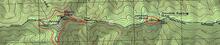
A few summit cores delineated by the National Terrain Mapping program in the Blue Ridge province, North Carolina. While many summits are mapped via the Geographic Names Information System points, boundaries for these features don't exist. This program is automating procedures to do so for the whole nation.
Sources/Usage
Public Domain.