
Avalon Tide Gage
By New Jersey Water Science Center
2024 (approx.)

Detailed Description
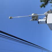
USGS 01411355 Ingram Thorofare at Avalon, New Jersey tide gage.
This site was moved from its original location near the marshes below, to a much higher elevation on the side of a nearby bridge.
Sources/Usage
Public Domain.
Related
New Jersey Precipitation and Weather Networks
The New Jersey Water Science Center provides valuable data augmentation to many locations for: Precipitation, Water and Air Temperature, and even Wind Speed and Direction at some of our coastal sites. Our technicians continuously make field measurements and maintain these networks to ensure the accuracy of these data.

New Jersey Tide Network
The USGS operates the most extensive network of tide-gaging stations in the region, many of which form the backbone of flood-warning and storm-hazard warning systems. The New Jersey Water Science Center monitors data for estuary and back-bay areas all along the New Jersey coast and links to related projects with more information about coastal flood hazards, water quality, and other topics. This...
Related
New Jersey Precipitation and Weather Networks
The New Jersey Water Science Center provides valuable data augmentation to many locations for: Precipitation, Water and Air Temperature, and even Wind Speed and Direction at some of our coastal sites. Our technicians continuously make field measurements and maintain these networks to ensure the accuracy of these data.
New Jersey Tide Network
The USGS operates the most extensive network of tide-gaging stations in the region, many of which form the backbone of flood-warning and storm-hazard warning systems. The New Jersey Water Science Center monitors data for estuary and back-bay areas all along the New Jersey coast and links to related projects with more information about coastal flood hazards, water quality, and other topics. This...