
Beach Profile Survey

Detailed Description
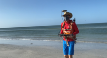
Justin Birchler, Physical Scientist with the USGS Coastal Change Hazards team conducts a beach profile survey at our field site on Madeira Beach. During these surveys, Justin wears a backpack with GPS equipment to collect elevation data that will be used to create a topographic map of the beach. These data help our team monitor coastal change – including how storms and waves shape and reshape our beaches. It’s important to keep track of how beaches change over time because they provide habitat for many creatures including birds and sea turtles, and they are beautiful locations where people love to live and vacation.
Learn more about Coastal Change Hazards research.
Sources/Usage
Public Domain.