
Care must be taken to make sure a high water mark is accurate.

Detailed Description
Find the high-water marks in these pictures
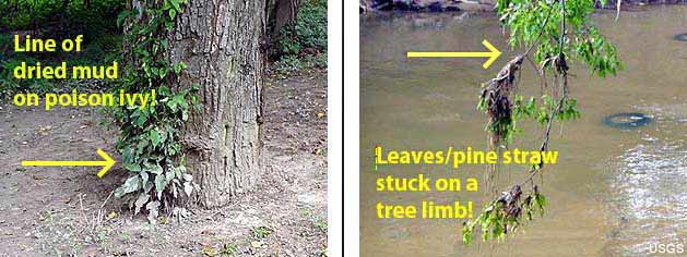
Below are a couple of pictures of Peachtree Creek in Atlanta, Georgia. The pictures were taken on the river bank next to Peachtree Creek a few days after high water occurred during a storm. USGS hydrologists visited the site to try to find out the peak river height during the storm. High-water marks are visible in both pictures, although a hydrologist would only regard one of the marks as being reliable.
The left picture shows a poison ivy vine with the bottom leaves covered in dried mud. The line where the mud stops indicated where muddy stormwater was flowing, and, thus, how high Peachtree Creek got during the storm. The right-side picture shows a limb that hangs over Peachtree Creek. During a flood, rapidly-moving water carries leaves, straw, and even whole trees! Wet leaves get stuck on limbs that are partially submerged in the stream. When the stream recedes the leaves remain on the limbs. The top of the leaves and pine straw indicate how high Peachtree Creek was during the storm.
The mud on the poison ivy vine is a much better high-water mark than the tree limb, though. During high water, part of the tree limb will be submerged in the fast-moving water, which will cause it to move up and down. Hydrologists would not use this type of high-water mark to estimate peak stream stage during a flood
Sources/Usage
Public Domain.
Related

High-Water Marks and Flooding
Related