
Checking Tide Sensors

Detailed Description
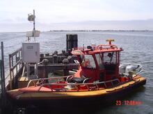
New Jersey Ambar docked at tide sensor on a bridge footer at East Thorofare at Ship Bottom, NJ (01409146).
Sources/Usage
Public Domain.
Related
Tidal Discharge at USGS Streamgages
New Jersey has an extensive coastline with several rivers and streams close enough to interact with the bays and ocean. This interaction causes many waterways to be affected by the tidal actions of the ocean. Because there are no dams along these rivers, this effect can be felt some distance upstream requiring specialized observational techniques to measure and calculate discharge from these...

Hurricanes and Storm-Tide Monitoring
The USGS works in partnership with other federal and state agencies to provide scientific data about coastal flood hazards. The New Jersey Water Science Center (NJWSC) maintains a network of continuously operating tide gages along the back bays of New Jersey which provide publicly available water-level and meteorological data to monitor coastal flood conditions. The USGS NJWSC coordinates with our...
Related
Tidal Discharge at USGS Streamgages
New Jersey has an extensive coastline with several rivers and streams close enough to interact with the bays and ocean. This interaction causes many waterways to be affected by the tidal actions of the ocean. Because there are no dams along these rivers, this effect can be felt some distance upstream requiring specialized observational techniques to measure and calculate discharge from these...
Hurricanes and Storm-Tide Monitoring
The USGS works in partnership with other federal and state agencies to provide scientific data about coastal flood hazards. The New Jersey Water Science Center (NJWSC) maintains a network of continuously operating tide gages along the back bays of New Jersey which provide publicly available water-level and meteorological data to monitor coastal flood conditions. The USGS NJWSC coordinates with our...