
New Jersey has an extensive coastline with several rivers and streams close enough to interact with the bays and ocean. This interaction causes many waterways to be affected by the tidal actions of the ocean. Because there are no dams along these rivers, this effect can be felt some distance upstream requiring specialized observational techniques to measure and calculate discharge from these rivers.

New Jersey has several major rivers or streams that discharge directly into tidal bays or the Atlantic Ocean. Some examples include the Hackensack, Passaic, and Raritan Rivers that all eventually flow into the Raritan Bay and the Cooper, Salem, Maurice, and Cohansey Rivers that flow into the tidal reach of the Delaware River and Delaware Bay and out into the Atlantic Ocean.
Although a quick view of these waterways makes them look like typical rivers, they are tidally influenced water bodies that typically experience a full tidal range twice a day. Because the major bay inlets around New Jersey are not controlled by dams, the ocean tides are free to travel upstream along many major rivers and inlet channels. One seemingly obvious example is the Delaware River, which is typically tidally influenced more than 100 miles from the mouth all the way up to Trenton, NJ.
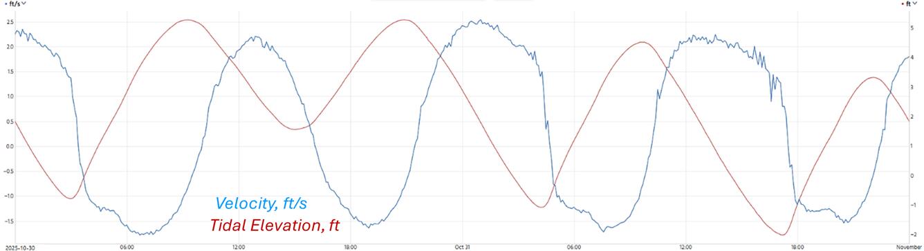
As a result of tidal influence being effective far upstream along certain rivers, USGS streamgages in these areas measure continuously changing water levels that naturally fluctuate throughout the day due to the influence of ocean tides. To accurately calculate streamflow in these tidally affected rivers, the USGS uses special fixed hydroacoustic instruments that continuously measure water velocity throughout the tidal cycle. The changing tides cause the flow in these rivers to reverse direction twice a day requiring the USGS to measure the water velocity in both directions. Streamflow in the downstream direction is designated as positive flow, while streamflow in the upstream direction is designated as negative flow. These data are then processed using an indexed-velocity method, which allows the USGS to relate a measured velocity from the instrumentation to the mean velocity in the channel and ultimately a reliable discharge in the river. These complex methods are required for calculating discharge in tidally affected rivers because simple methods of relating a water level to a single specific flow are invalid under these conditions. Traditional non-tidal USGS methods for computing discharge from measured water levels assume a one directional relation and that higher water levels mean more flow, which is not always true for a tidal location. Notice in the image below that the tidal elevation (red) peaks do not align with the velocity (blue).
Just like traditional USGS streamgages that use the simpler stage-discharge method require routine discharge measurements, tidal streamgages also require routine discharge measurements. These measurements are used to develop new stage-discharge relationships and to maintain the calibration of existing stage-discharge relations. For tidal rivers, discharge measurements are collected in a way that captures short and long-term variations in tidal flow. This typically involves measuring continuously for at least one-fourth to one-half of a tidal cycle (about 7 to 13 hours) at least once per year. Hydrographers typically collect these measurements using acoustic instruments such as Acoustic Doppler Velocity Profilers (ADCPs) from bridges or boats.
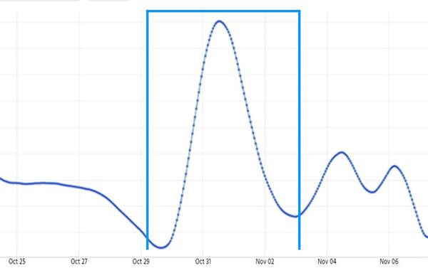
Daily tidal fluctuations typically obscure the non-tidal base flow and runoff hydrograph entering the tidally influenced reach. USGS Hydrographers apply a low-pass filter (the Godin Filter is typically used) calibrated to the local tidal signal to filter the tidal pattern in the continuous unit-value time series data and reveal the non-tidal base flow and runoff hydrograph. Using the filter to remove the tidal signal allows daily hydrologic statistics to be computed that reflect the non-tidal watershed conditions. For example, on the Rancocas Creek at Bridgeboro, NJ, a rain event occurred on 10/31/2025 which registered at the co-located weather station (400145074555401). Using the index velocity method, discharge was calculated. This data was then put through the Godin Filter to compute the tidally filtered discharge. Notice how the rain event was not obvious in the index velocity dataset, but clear in the tidally filtered time series.

New Jersey Tide Network
New Jersey has an extensive coastline with several rivers and streams close enough to interact with the bays and ocean. This interaction causes many waterways to be affected by the tidal actions of the ocean. Because there are no dams along these rivers, this effect can be felt some distance upstream requiring specialized observational techniques to measure and calculate discharge from these rivers.
New Jersey has several major rivers or streams that discharge directly into tidal bays or the Atlantic Ocean. Some examples include the Hackensack, Passaic, and Raritan Rivers that all eventually flow into the Raritan Bay and the Cooper, Salem, Maurice, and Cohansey Rivers that flow into the tidal reach of the Delaware River and Delaware Bay and out into the Atlantic Ocean.
Although a quick view of these waterways makes them look like typical rivers, they are tidally influenced water bodies that typically experience a full tidal range twice a day. Because the major bay inlets around New Jersey are not controlled by dams, the ocean tides are free to travel upstream along many major rivers and inlet channels. One seemingly obvious example is the Delaware River, which is typically tidally influenced more than 100 miles from the mouth all the way up to Trenton, NJ.
As a result of tidal influence being effective far upstream along certain rivers, USGS streamgages in these areas measure continuously changing water levels that naturally fluctuate throughout the day due to the influence of ocean tides. To accurately calculate streamflow in these tidally affected rivers, the USGS uses special fixed hydroacoustic instruments that continuously measure water velocity throughout the tidal cycle. The changing tides cause the flow in these rivers to reverse direction twice a day requiring the USGS to measure the water velocity in both directions. Streamflow in the downstream direction is designated as positive flow, while streamflow in the upstream direction is designated as negative flow. These data are then processed using an indexed-velocity method, which allows the USGS to relate a measured velocity from the instrumentation to the mean velocity in the channel and ultimately a reliable discharge in the river. These complex methods are required for calculating discharge in tidally affected rivers because simple methods of relating a water level to a single specific flow are invalid under these conditions. Traditional non-tidal USGS methods for computing discharge from measured water levels assume a one directional relation and that higher water levels mean more flow, which is not always true for a tidal location. Notice in the image below that the tidal elevation (red) peaks do not align with the velocity (blue).
Just like traditional USGS streamgages that use the simpler stage-discharge method require routine discharge measurements, tidal streamgages also require routine discharge measurements. These measurements are used to develop new stage-discharge relationships and to maintain the calibration of existing stage-discharge relations. For tidal rivers, discharge measurements are collected in a way that captures short and long-term variations in tidal flow. This typically involves measuring continuously for at least one-fourth to one-half of a tidal cycle (about 7 to 13 hours) at least once per year. Hydrographers typically collect these measurements using acoustic instruments such as Acoustic Doppler Velocity Profilers (ADCPs) from bridges or boats.
Daily tidal fluctuations typically obscure the non-tidal base flow and runoff hydrograph entering the tidally influenced reach. USGS Hydrographers apply a low-pass filter (the Godin Filter is typically used) calibrated to the local tidal signal to filter the tidal pattern in the continuous unit-value time series data and reveal the non-tidal base flow and runoff hydrograph. Using the filter to remove the tidal signal allows daily hydrologic statistics to be computed that reflect the non-tidal watershed conditions. For example, on the Rancocas Creek at Bridgeboro, NJ, a rain event occurred on 10/31/2025 which registered at the co-located weather station (400145074555401). Using the index velocity method, discharge was calculated. This data was then put through the Godin Filter to compute the tidally filtered discharge. Notice how the rain event was not obvious in the index velocity dataset, but clear in the tidally filtered time series.