
Continuous habitat suitability map and associated data for cheatgrass in the United States within and near Crater Lake National Park

Detailed Description
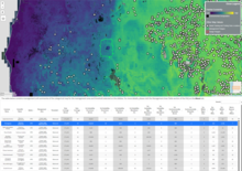
A screenshot from the Invasive Species Habitat Tool (INHABIT) 4.0 displaying continuous habitat suitability for cheatgrass (Bromus tectorum) across central Oregon. Darker, purple color indicates low habitat suitability and lighter, yellower colors indicate higher habitat suitability, black indicates environmental extrapolation is limited. White dots represent locations of data used to estimate habitat suitability. The green polygon represents Crater Lake National Park and a scale in the bottom left displays map distances.
Below, a screenshot of the Summary by Management area tab from INHABIT 4.0 for cheatgrass displays data specific to Crater Lake National Park, including information about how many acres in the park are considered suitable habitat for cheatgrass (126,024 or 69% of the entire park), how many acres in the park are estimated to be suitable for high abundance in of cheatgrass (495), and the closest known cheatgrass occurrence (7 miles from the park), among other information relevant to managers. (Abbreviations: Est=Estimated; Occ=Occurrences; Dist=Distance). All data in the Summary by Management Area and Summary by Species tabs are downloadable.
Sources/Usage
Public Domain.
Related

INHABIT: A web tool for invasive plant management across the contiguous United States
Related