
Field work in the Columbia River Littoral Cell
By Pacific Coastal and Marine Science Center
2019 (approx.)

Detailed Description
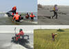
Photographs showing equipment used during bathymetric and topographic surveys along the Columbia River littoral cell, Washington and Oregon.
Sources/Usage
Public Domain.