
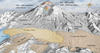
Digital Elevation Map of Mount St. Helens pre and post 1980

Detailed Description
The shaded relief image was produced from LIDAR data. LIDAR is an acronym for Light Detection and Ranging, a modern remote sensing technique used to map topography very accurately—more so than is possible with older techniques. The crater is 1.2 miles (1.9km) wide east-west. Elsewhere the scale varies owing to the oblique viewing angle. The landslide deposit includes the hummocks deposited to the northwest, and the location where the debris avalanche ruan-up a steep south-facing slope (bottom of image). The pumice plain is the location of a large fallout deposit from the Plinian phase of the eruption. Age of the domes in the center of the crater is indicated in the call-out text.
Sources/Usage
Public Domain.