
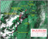
Distribution of active breakouts on June 27th lava flow

Detailed Description
This satellite image was captured on Friday, December 19, by the Advanced Land Imager instrument onboard NASA's Earth Observing 1 satellite. Although this is a false-color image, the color map has been chosen to mimic what the human eye would expect to see. Bright red pixels depict areas of very high temperatures and show active lava. White areas are clouds.
The upslope portion of the June 27th flow, near Pu‘u ‘Ō‘ō, is obscured by clouds, but the downslope portion of the flow near Pāhoa is relatively cloud free. The image provides a clear view of the distribution of active breakouts on this downslope portion of the flow. Surface lava is active around the leading tip of the flow, marked as "active flow front", but a short distance upslope of the leading tip there is an absence of surface breakouts. About 1.5-2 km (0.9-1.2 miles) upslope of the leading tip of the flow, many scattered breakouts are present. This image emphasizes that activity on the June 27th flow is not limited to the flow front.