
Earth MRI Acquisitions Viewer: Snapshot View
Detailed Description
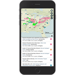
Snapshot zoom view of Earth MRI Acquisitions Viewer map showing acquisition areas in the eastern continental U.S. Geophysical, geological, lidar, and geochemistry data are being acquired under Earth MRI in partnership with state geological surveys and other federal agencies, for example, Department of Energy. The viewer is used to explore these areas, associated project information, and access data when published. Learn more at https://ngmdb.usgs.gov/emri
Sources/Usage
Public Domain.