
False-Color Landsat 8 Operational Land Imager

Detailed Description
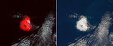
(Left) False-Color Landsat 8 Operational Land Imager scene of Saunders Island and Mount Michael on January 31, 2018. This image is composed from red and shortwave infrared light detected by the satellite sensors. Blue represents the high temperature ground surface that includes the lava lake. Snow and ice appear red and meteorological clouds and the volcanic vapor and gas plume are gray. (Right) The same scene in natural color without benefit of the spectral discrimination of high temperatures. Note that the lava lake is not easy to see. Images courtesy of NASA.
Sources/Usage
Public Domain.