
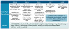
Fieldwork timeline

Detailed Description
Fieldwork Plans/Goals of the USGS Cascadia Subduction Zone Marine Geohazards project.
Partners in all fieldwork: NOAA, BOEM, Ocean Exploration Trust, Humboldt State University, University of Washington, Oregon State University, Scripps Institution of Oceanography, University of Hawaii, Woods Hole Oceanographic Institution, MBARI, U.S. Nation Park Service, and NSF
2018
Multibeam bathymetry & backscatter across the upper slope (200 -1200m water depth)
High-resolution 2-D geophysical surveys (Chirp subbottom, Sparker MCS, Magnetometer) Southern Cascadia
2019
High-resolution 2-D geophysical surveys (Chirp subbottom, Sparker MCS) Northern Cascadia
Astoria Canyon sediment dynamics: (Chirp, Moorings)
Seabed Sampling: (Piston and gravity cores)
2020
Margin-wide OBS deployments coordinated with crustal-scale MCS surveys
Targeted AUV/ROV surveys and sampling Southern Cascadia
Installation of 2 new GPS-A seafloor geodetic stations in Southern Cascadia
2021
Seabed Sampling: (Piston and gravity cores)
Targeted AUV/ROV surveys and sampling Northern Cascadia
Related Activities: Development of rapid-response OBS capabilities; integration of onshore-offshore fault mapping; lake paleoseismology
2022
Follow-up work in Cascadia, Alaska, or other subduction zones
Related Activities: Development of rapid-response OBS capabilities; integration of onshore-offshore fault mapping; lake paleoseismology
Sources/Usage
Public Domain.
Related

Cascadia Subduction Zone Marine Geohazards
Related