
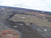
Five different flows—two erupted prehistorically and three others e...

Detailed Description
To construct a geologic map of this area, USGS Hawaiian Volcano Observatory geologists initially used lava flow type, rock colors, and relative stratigraphic positions to distinguish between individual lava flows, and then relied on laboratory analyses and age-dates of the flows to refine their field mapping. USGS photo.
Related

Geology and History of Mauna Loa
Mauna Loa is the largest active volcano on Earth. Mauna Loa is in the shield-building stage of Hawaiian volcanism, a period when the volcanoes grow most rapidly, adding as much as 95 percent of their ultimate volume.
Related
Geology and History of Mauna Loa
Mauna Loa is the largest active volcano on Earth. Mauna Loa is in the shield-building stage of Hawaiian volcanism, a period when the volcanoes grow most rapidly, adding as much as 95 percent of their ultimate volume.