
Florida Keys showing sites where calcification monitoring

Detailed Description
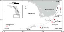
Map of the Florida Keys showing sites (red stars) where calcification monitoring stations are located. Our work occurs within the boundaries of Biscayne National Park, the Florida Keys National Marine Sanctuary, and Dry Tortugas National Park. Stations are on the outer-reef tract in approximately 12 to 15 feet (4 to 5 m) of water depth in relic spur-and-groove or hard-bottom habitat.
Sources/Usage
Public Domain.
Related

Measuring Coral Growth to Help Restore Reefs
It is critical to start measuring calcification rates in a systematic way now, particularly at subtropical latitudes where conditions fluctuate seasonally, so that we can understand how dynamic ocean conditions affect calcifying organisms today and predict possible changes in the future. We established a calcification monitoring network in the Florida Keys and have been measuring calcification...
Related
Measuring Coral Growth to Help Restore Reefs
It is critical to start measuring calcification rates in a systematic way now, particularly at subtropical latitudes where conditions fluctuate seasonally, so that we can understand how dynamic ocean conditions affect calcifying organisms today and predict possible changes in the future. We established a calcification monitoring network in the Florida Keys and have been measuring calcification...