
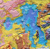
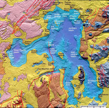
High-resolution bathymetric relief map of Yellowstone Lake

Detailed Description
High-resolution bathymetric relief map of Yellowstone Lake, acquired by multibeam sonar imaging and seismic mapping, surrounded by colored geologic map of the area around Yellowstone Lake. The map shows some of the large hydrothermal explosion crater locations, including Mary Bay (13,000 years ago), Turbid Lake (9,400 years ago) and Indian Pond (2,900 years ago). Map generated by Lisa Morgan, USGS.
Sources/Usage
Public Domain.
Morgan et al. 2003