
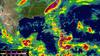
Hurricane Mathew Rainfall Map 2016

Detailed Description
Infrared satellite image showing the amount of rainfall in South and North Carolina during the period from September 28 through October 10, 2016 (National Aeronautics and Space Administration https://www.nasa.gov/feature/goddard/2016/matthew-atlantic-ocean, NASA/JAXA, Hal Pierce). The areas in purple show highest rainfall amounts.