
HVO shares its research with the international scientific community

Detailed Description
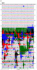
This is a helicorder seismogram displaying vertical ground velocities at the summit of Hualālai volcano south of the earthquake epicenters. Each line represents 10 minutes and time increases from left to right. Each line continues on the line below. The seismogram starts at 2 am and ends at 2 pm HST on October 15, 2006.
The top 26 lines show typical ground vibrations before the earthquake. The M6.7 earthquake immediately goes off scale. The M6.0 earthquake arrives on the line below. Each of the signals that resemble Christmas trees turned horizontal are aftershocks.