
Hydrologic Unit Code (HUC) overview
Detailed Description
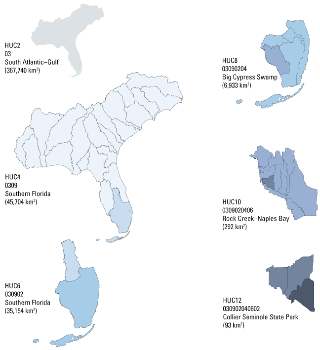
The U.S. Geological Survey uses a depiction and classification scheme for hydrologic units known as hydrologic unit codes (HUCs). HUCs generally represent catchments, and river basins are represented by a unique series of numbers with successively smaller hydrologic units nested inside of larger ones. Digits are added as hydrologic units become smaller, such that a 2-digit HUC encompasses multiple 4-digit HUCs, and a 4-digit HUC encompasses multiple 6-digit HUCs, etc. This assessment uses 12-digit HUCs (HUC12s), which generally range from 50 to 100 square kilometers (km^2) in size. The CONUS contains 18 2-digit HUCs and over 93,000 12-digit HUCs. The HUC12 median areal extent in the conterminous United States is 90 km^2. Although in practice, HUCs represent river basins, they are formally administrative units, and not always natural watersheds. As such, HUCs can depict human-created drainages and diversions or arbitrary breaks in connected flow systems.
Image illustrates this nesting of hydrologic unit codes (HUCs), which result in successively smaller drainage units and add digits to the HUC to create a unique “address.”
Figure S5.1 from https://doi.org/10.3133/pp1894A
Sources/Usage
Public Domain.