
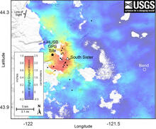
Interferogram spanning 2020-2021 and showing uplift west of South Sister
By Cascades Volcano Observatory
2021 (approx.)

Detailed Description
Satellite radar interferogram spanning June 19, 2020, to August 13, 2021, and showing the ground motion in the direction of the satellite. The maximum uplift, indicated by the red color, is about 2.2 centimeters (0.85 inches), and it is located to the west of South Sister. The HUSB continuous GPS site is marked by the large black dot. Earthquakes that occurred during the time period spanned by the interferogram are indicated by small black dots.
Sources/Usage
Public Domain.
Related

Modern Deformation and Uplift in the Sisters Region
In 2001, scientists discovered a broad area of uplift west of South Sister that had been rising a few cm (inches) per year since the 1990s. Uplift rates have varied, with a new pulse starting in 2020–2021. Geochemistry data indicate that magmatic activity in the region predates the past few decades.
Related
Modern Deformation and Uplift in the Sisters Region
In 2001, scientists discovered a broad area of uplift west of South Sister that had been rising a few cm (inches) per year since the 1990s. Uplift rates have varied, with a new pulse starting in 2020–2021. Geochemistry data indicate that magmatic activity in the region predates the past few decades.