
Landsat 8 Image of the Great Salt Lake in July, 2022

Detailed Description
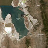
Natural Color Landsat 8 image of the Great Salt Lake, acquired on July 3, 2022. On July 3, the level of Great Salt Lake dropped below the October 2021 historic low elevation. This average daily surface water elevation, 4,190.1 feet, was measured at USGS station 10010000, located on the southern end of the lake and is associated with a data record dating back to 1847.
Learn more about the Landsat mission at https://www.usgs.gov/landsat-missions/
Learn more about the Great Salt Lake from the Utah Water Science Center
Sources/Usage
Public Domain.