
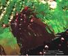
Landsat 8 satellite image of Pu‘u ‘Ō‘ō flow field

Detailed Description
This image was captured on Tuesday, December 10 by Landsat 8, a new NASA Earth-observing satellite that was launched in February of this year and entered service in May. The image shows the Pu‘u ‘Ō‘ō lava flow field on Kīlauea's east rift zone. Although this is a false-color image, the color map has been chosen to mimic what the human eye would expect to see. Breakouts, shown by the bright red pixels, are active at the far end of the Kahauale‘a 2 flow (click "map" link above for the current flow field map, which shows the extent of the Kahauale‘a 2 flow). These active flows are slowly advancing into the forest, and extend to about 5.8 km (3.6 miles) northeast of the vent on Pu‘u ‘Ō‘ō cone. Satellite images such as this help fill in observational gaps between field visits.
Sources/Usage
Public Domain.