
Landsat Collection 2 Fractional Snow Covered Area (fSCA) Grid Map

Detailed Description
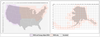
This map shows where Landsat Collection 2 fractional Snow Covered Area (fSCA) and Canopy Adjusted fSCA data is available for the conterminous United States (top) and Alaska (below). To learn more visit the Landsat Collection 2 fSCA science products web page.
Sources/Usage
Public Domain.
Related

USGS EROS Archive - Landsat Collection 2 Level-3 Fractional Snow Covered Area (fSCA) Science Product
Landsat Collection 2 Level-3 Fractional Snow Covered Area (fSCA) contains per-pixel fractional snow cover maps that indicate the percentage of a pixel covered by snow.
Related
USGS EROS Archive - Landsat Collection 2 Level-3 Fractional Snow Covered Area (fSCA) Science Product
Landsat Collection 2 Level-3 Fractional Snow Covered Area (fSCA) contains per-pixel fractional snow cover maps that indicate the percentage of a pixel covered by snow.