
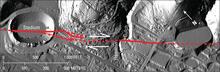
Lidar shaded relief map of the Hayward Fault and UC Berkeley stadium
By Communications and Publishing
2008 (approx.)

Detailed Description
A filtered vertical laser image, taken using a technique called light detection and ranging (LIDAR), of part of the Hayward Fault (red lines) in the City of Berkeley. The fault passes through the University of California Berkeley football stadium (left), and past earthquake movements have significantly offset Hamilton Gulch (center). Arrows show relative movement on the fault.
Sources/Usage
Public Domain.