
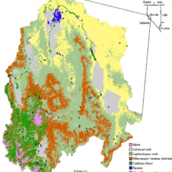
Location of Walker River Basin and its eight major vegetation types

Detailed Description
Location of Walker River Basin (17) and its eight major vegetation types, as well as developed areas. Piñon-juniper woodland and montane shrubland tend to be highly interspersed and were combined for visual clarity. Because meadows occurred in very small patches, they could not be represented on this map. Map generated at Utah State University as part of the GAP conservation mapping project.
John D. Boone, K.McGwire, E.Otteson, R. DeBaca, E. Kuhn, P. Villard, P. Brussard, and S. St. Jeor, Remote Sensing and Geographic Information Systems: Charting Sin Nombre Virus Infections in Deer Mice, Emerging Infectious Diseases, Vol. 6, No. 3.
Sources/Usage
Public Domain.
Related
Gap Analysis Example Applications
Learn about some of the ways Gap Analysis is being applied.
Related
Gap Analysis Example Applications
Learn about some of the ways Gap Analysis is being applied.