
Long Island Sound SEABOSS Survey

Detailed Description
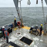
A seafloor mapping survey in Long Island Sound took place in May with collaborators from the University of Connecticut and the University of New Haven. They are mapping the area’s geology and biota to identify seasonal changes from their previous survey in November 2024. The USGS is mainly involved with seabed classification and characterizing the geologic framework of the region using bathymetry, backscatter, seismic reflection, and sediment samples, videos, and photos.
Sources/Usage
Public Domain.
Related
Coastal and Marine Science in Long Island Sound
Long Island Sound is a highly productive estuary and vital natural resource bordering New York and Connecticut. It’s essential for its massive economic impact, generating billions annually by supporting recreation, fisheries, and transportation, as well as its biodiversity, serving as a critical habitat for thousands of marine species. USGS research in Long Island Sound helps protect these...