
Low density lidar error
By NGP Standards and Specifications
2021 (approx.)

Detailed Description
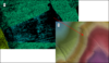
Lidar error dictionary figure 15. Classified point cloud (A) with an area of lower point density that detrimentally affects the digital elevation model (DEM) (B). An area with TIN artifacts can be seen in the DEM in the area of lower density.
Sources/Usage
Public Domain.