
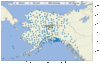
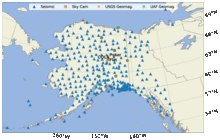
Map of All-Sky, Geomagnetic & Seismic Instrument Locations in Alaska

Detailed Description
Map of instrument locations used in both studies. The triangle symbols depict seismic stations including the Transportable Array (TA) and the Alaska Regional Network (AK). The 6 all-sky cameras are depicted in red squares at Kaktovik, Toolik, Fort Yukon, Poker Flat, Eagle, and Gakona. The magnetic stations are depicted as orange circles (USGS; 5 stations) and green circles (University of Alaska Fairbanks; 8 stations). (modified from original, Adam Ringler)
Sources/Usage
Public Domain.
Related

Auroras and Earthquakes: Strange Companions
Release Date: JULY 6, 2020 In 1722 and 1723 a London clockmaker, George Graham, observed daily and consistent variations on one of his instruments, a “Needle upon the Pin” (a compass), for which he had no explanation. Swedish scientists obtained some of Graham’s instruments to record what is now known to be the variations in Earth’s magnetic field. In 1741, they noticed a significant deflection of...
Related
Auroras and Earthquakes: Strange Companions
Release Date: JULY 6, 2020 In 1722 and 1723 a London clockmaker, George Graham, observed daily and consistent variations on one of his instruments, a “Needle upon the Pin” (a compass), for which he had no explanation. Swedish scientists obtained some of Graham’s instruments to record what is now known to be the variations in Earth’s magnetic field. In 1741, they noticed a significant deflection of...