
Map of June 27th flow in Kīlauea's ERZ

Detailed Description
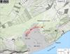
Map showing the June 27th flow in Kīlauea's East Rift Zone as of August 22, 2014. The area of the flow as mapped on August 12 is shown in pink, while widening and advancement of the flow as of August 22 is shown in red. The heavy brown line marks the extent of steaming along a ground crack into which lava is flowing. Though lava is not visible within the crack, it is inferred that lava is using the crack as a pathway to continue its advance to the northeast. A more northerly branch of the flow is entering a different part of the forest about midway along the length of the flow. All older lava flows (1983-2014) are shown in gray. The thin yellow line marks a portion of the lava tube feeding the flow.
Sources/Usage
Public Domain.