
Map of Tertiary intrusive magmatism in the southern Rocky Mountains

Detailed Description
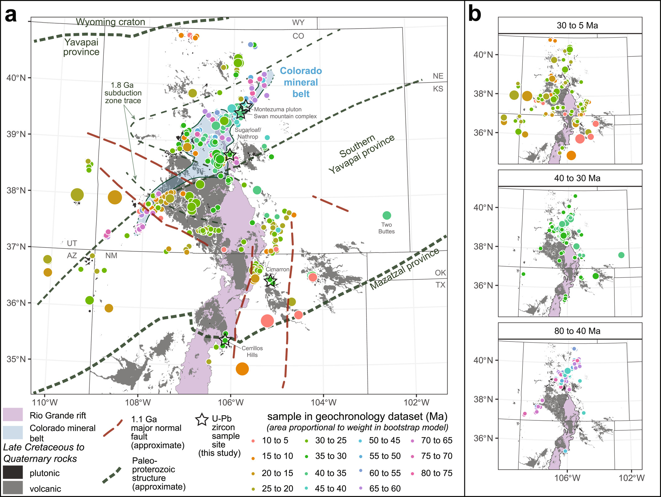
Maps of the southern Rocky Mountain region hosting the Colorado Mineral Belt (CMB) showing locations of Late Cretaceous to Miocene geochronological samples and simplified geological features. While there is a significant amount of existing data, many of these ages do not reflect crystallization ages due to thermal resetting or issues associated with older analytical methods. As a result, there is a significant amount of critical work to be done in this region to understand the formation of the CMB, its mineral deposits and how it relates to surrounding regions. (A) Overview of the region, simplified geological features, and existing geochronological data. Proterozoic structures modified after Jessup et al. (2005), G. R. Keller et al. (2005), and Whitmeyer and Karlstrom (2007). Rio Grande rift outline modified after Hudson and Grauch (2013), Colorado mineral belt outline modified after Chapin (2012) and Tweto and Sims (1963), and igneous rock units modified after Horton et al. (2017). (B) Time-slice panels showing the spatial distribution of samples from rocks formed during the Laramide orogeny (80 to 40 Ma), post-Laramide transition (40 to 30 Ma), and extension and rifting (30 to 5 Ma). Figure from Rosera et al. (2024).
References
Chapin, C.E., 2012, Origin of the Colorado mineral belt: Geosphere, 8(1), 28–43, doi: 10.1130/GES00694.1.
Horton, J.D., San Juan, C.A., and Stoeser, D.B., 2017, The State Geologic Map Compilation (SGMC) geodatabase of the conterminous United States (ver. 1.1, August 2017): U.S. Geological Survey Data Series 1052, 46 p., doi: 10.3133/ds1052.
Hudson, M.R., and Grauch, V.J.S., 2013, Introduction, in M.R. Hudson and V.J.S. (Tien) Grauch (Eds.), New Perspectives on Rio Grande Rift Basins: From Tectonics to Groundwater: Geological Society of America Special Paper, v. 494, v-xii, doi: 10.1130/2013.2494(00).
Jessup, M.J., Karlstrom, K.E., Connelly, J., Williams, M., Livaccari, R., Tyson, A., and Rogers, S A., 2005, Complex Proterozoic crustal assembly of southwestern North America in an arcuate subduction system: The Black Canyon of the Gunnison, southwestern Colorado, in K.E. Karlstrom and G.R. Keller (Eds.), The Rocky Mountain Region: An Evolving Lithosphere: American Geophysical Union Geophysical Monograph Series, v. 154, p. 21–38, doi: 10.1029/154GM03.
Keller, G.R., Karlstrom, K.E., Williams, M.L., Miller, K.C., Andronicos, C., Levander, A.R., Snelson, C.M., and Prodehl, C., 2005, The dynamic nature of the continental crust-mantle boundary: Crustal evolution in the Southern Rocky Mountain Region as an example, in K.E. Karlstrom and G. R. Keller (Eds.), The Rocky Mountain Region: An Evolving Lithosphere: American Geophysical Union Geophysical Monograph Series, v. 154, p. 403–420, doi: 10.1029/154GM30.
Rosera, J.M., Gaynor, S.P., Ulianov, A., and Schaltegger, U., 2024, Using stochastic point pattern analysis to track regional orientations of magmatism during the transition to Cenozoic extension and Rio Grande rifting, southern Rocky Mountains: Tectonics, 43, e2023TC007902, doi: 10.1029/2023TC007902.
Tweto, O., and Sims, P.K., 1963, Precambrian ancestry of the Colorado mineral belt: Geological Society of America Bulletin, v. 74, p. 991–1014, doi: 10.1130/0016-7606(1963)74[991:paotcm]2.0.co;2.
Whitmeyer, S.J., and Karlstrom, K.E., 2007, Tectonic model for the Proterozoic growth of North America: Geosphere, 3 (4): 220–259, doi: 10.1130/GES00055.1.
Sources/Usage
Public Domain.