
Methane Seeps Map

Detailed Description
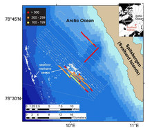
Ocean waters overlying shallow-water (260-295 feet; 80-90 meters) methane seeps (white dots) offshore the western margin of the Svalbard Islands absorb substantially more atmospheric carbon dioxide than the methane that they emit to the atmosphere. Colors indicate the strength of the negative greenhouse warming potential associated with carbon dioxide influx to these surface waters relative to the positive greenhouse warming potential associated with the methane emissions. Gray shiptracks have background values for the relative greenhouse warming potential.
Sources/Usage
Public Domain.