
New USGS video about Kīlauea's summit eruption is now online

Detailed Description
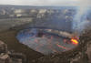
The lava lake within Halema‘uma‘u, a crater at the summit of Kīlauea, was about 30 m (98 ft) below the vent rim on the day of this photo (January 7, 2016). Orange lines on the lake surface were the result of lava lake circulation; as lava moved from left to right, sections of the dark-colored, semi-solid lake surface pulled apart, revealing incandescent molten lava beneath the crust. Vigorous spattering (bright yellow area at right) often occurs where circulating lava sinks back into the lake. USGS photo by T. Orr.
Sources/Usage
Public Domain.