
Next Generation Water Observing System Infographic
By Water Resources Mission Area
August 2019 (approx.)

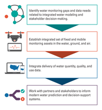
Detailed Description
USGS's NGWOS will integrate fixed and mobile monitoring assets in the water, ground, and air, including innovative webcams and new ground- and space-based sensors. When fully implemented, the NGWOS will provide high temporal and spatial resolution data on streamflow, evapotranspiration, snowpack, soil moisture, water quality, groundwater/ surface water connections, stream velocity distribution, sediment transport, and water use. USGS partner and stakeholder needs are helping to inform the NGWOS design so that data and information generated by the NGWOS will help them anticipate water shortages more accurately and react to water hazards more quickly.
Sources/Usage
Public Domain.