
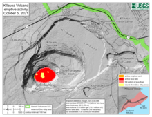
October 5, 2021—Kīlauea summit eruption reference map

Detailed Description
This reference map depicts the ongoing Kīlauea summit eruption on October 5, 2021. Two eruptive vents are active at this time: one along the western edge of the rising lava lake, and one within the south-central portion of the lake. Several islands from the December 2020–May 2021 eruption dot the lake surface, some of which were initially drowned but later floated back to the surface. Note that this map depicts contour elevations in feet, with the surface of the lava lake now at approximately 2530 ft (771 m) above sea level. At this time, active lava is visible from two public visitor overlooks in Hawai‘i Volcanoes National Park: a site along the trail between Kīlauea Overlook and Uēkahuna can see the southeastern edge of the lava lake, and a section of the Keanakāko‘i Overlook can see fountains at the western eruptive vent. Visit the park eruption page for more info: https://go.nps.gov/new-eruption.
Sources/Usage
Public Domain.