
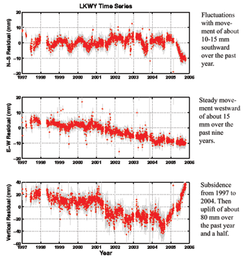
Plots of movement at the LKWY GPS station from 1997 - 2006, YNP.

Detailed Description
Relative movement of the LKWY GPS station from 1997 to 2006 (there was no Norris station until 2003; this one sits at the north end of Yellowstone Lake). The top image shows north-south movement, the middle image shows east-west
movement, and the bottom image shows vertical movement. During the period of uplift in the northern part of the caldera, the LKWY station was subsiding. Recently, this and other stations have moved upwards.
Sources/Usage
Public Domain.