
The Rise and Fall of the Delaware Salt Front

Detailed Description
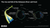
The rise and fall of the Delaware River salt front. Over time, the location of the salt front moves in response to regional weather patterns, sea level rise, and human impacts. The precise location of the salt front in the Delaware River Basin is based on the location in the river where the average chloride concentration is 250 mg/L. Two polar charts show the location of the salt front along the Delaware River in 2016 and 2019. When there is lots of precipitation, as was the case in early 2019, increased flow in the Delaware River pushes the salt front downstream. When conditions are very dry, as was the case in fall 2016, the salt front gradually moves further and further upstream, passing Wilmington, Delaware, and nearing Philadelphia, Pennsylvania. During both years, the salt front is highest upstream, encroaching Philadelphia, during the months of September, October, and November, while located further downstream below Wilmington from Jan – June.
Sources/Usage
Public Domain.