Sampling operations on Lake Superior

Detailed Description
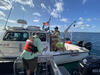
The RV Desmid (foreground) alongside the RV Rafael during sampling operations on Lake Superior.
Sources/Usage
Public Domain.

Official websites use .gov
A .gov website belongs to an official government organization in the United States.
Secure .gov websites use HTTPS
A lock () or https:// means you’ve safely connected to the .gov website. Share sensitive information only on official, secure websites.
The RV Desmid (foreground) alongside the RV Rafael during sampling operations on Lake Superior.
Public Domain.