
Satellite image shows active breakouts on flow field

Detailed Description
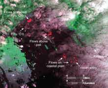
This image was captured on Wednesday, February 13, by the Advanced Land Imager sensor aboard NASA's Earth Observing 1 satellite. Although this is a false-color image, the color map has been chosen to mimic what the human eye would expect to see. Bright red pixels depict areas of very high temperatures, and show active or very recently active lava flows. The image shows three general areas of active breakouts. First, flows have been active for several weeks northeast of Pu‘u ‘Ō‘ō, and have reached about 2 km (1.2 miles) from the Pu‘u ‘Ō‘ō crater rim. Second, breakouts have been active above the pali, about 5 km (3.1 miles) southeast of Pu‘u ‘Ō‘ō. Third, several scattered breakouts have been active on the coastal plain, with several patches very close to the shoreline above the active ocean entry. Satellite images such as this help fill in observational gaps between field visits.