
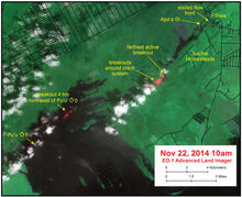
Satellite image shows areas of active breakouts on June 27th lava flow

Detailed Description
This satellite image was captured by the Advanced Land Imager instrument onboard NASA's Earth Observing 1 satellite. Although this is a false-color image, the color map has been chosen to mimic what the human eye would expect to see. Bright red pixels depict areas of very high temperatures and show active lava. White areas are clouds.
Although the farthest tip of the June 27th lava flow, in Pāhoa, is stalled, this image shows that breakouts remain active upslope. These breakouts are focused in two areas. First, there is a breakout about 4 km (2.5 miles) northeast of Pu‘u ‘Ō‘ō. Second, breakouts are active in the area of ground cracks farther downslope. The farthest tip of these breakouts has advanced a short distance north over the past day and was 5.8 km (3.6 miles) upslope of AP‘A‘ā St. as measured along a straight line.