
Satellite image shows June 27th lava flow

Detailed Description
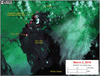
This satellite image was captured on March 2 by the Advanced Land Imager instrument onboard NASA's Earth Observing 1 satellite. The image is provided courtesy of NASA's Jet Propulsion Laboratory. Although this is a false-color image, the color map has been chosen to mimic what the human eye would expect to see. Bright red pixels depict areas of very high temperatures and show active lava. White areas are clouds. Black lines are roads.
The image shows that scattered breakouts remain active northeast of Pu‘u ‘Ō‘ō. Many of these breakouts are active along the northern flow field margin, at the forest boundary. A small portion of these flows at the forest boundary have migrated north, slightly closer to subdivisions. The overall ground slope, however, is towards the northeast, and other recent flows that have been active in this area have all eventually migrated along the direction of the arrow on the map - maintaining a safe distance from the subdivisions towards the north.
A bright thermal anomaly in Pu‘u ‘Ō‘ō Crater results from an active flow that was covering the crater floor at the time of the satellite overpass.