
Satellite image shows Pu‘u ‘Ō‘ō lava flow

Detailed Description
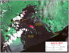
This satellite image was captured on June 21 by the Advanced Land Imager instrument onboard NASA's Earth Observing 1 satellite. The image is provided courtesy of NASA's Jet Propulsion Laboratory. Although this is a false-color image, the color map has been chosen to mimic what the human eye would expect to see. Bright red pixels depict areas of very high temperatures and show active lava. White areas are clouds.
The image shows continued advancement of the flow towards the southeast. Active surface breakouts, shown by red pixels, are limited to the area of the flow front. Lava tubes beneath the surface supply lava to these breakouts from the vent.