
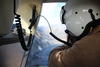
Scientist collects data—Kīlauea eruption overflight—Oct. 15, 2021

Detailed Description
Hawaiian Volcano Observatory scientists make observations and collect data during Kīlauea eruption overflights. The data collected is used to construct updated topographic and thermal maps of the lava lake surface and surrounding area. By comparing the updated maps to previous maps, scientists will be able to track changes in the volume, surface elevation, eruption features, and thermal changes. USGS photo taken during the October 15 overflight by N. Deligne.
Sources/Usage
Public Domain.