
Screenshot of Total Water Level and Coastal-Change Forecast Viewer
By Coastal and Marine Hazards and Resources Program
2016 (approx.)

Detailed Description
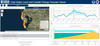
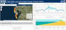
Screenshot of Total Water Level and Coastal-Change Forecast Viewer (<https://coastal.er.usgs.gov/hurricanes/research/twlviewer/>) on June 4, 2016, two days before Tropical Storm Colin was expected to hit Florida’s Gulf of America coast. This forecast is for Treasure Island (blue balloon on left-hand map) on the day of Colin’s arrival (June 6, 2016). It shows the expected total water level (top right), expected height of the water relative to the height of the beach dune (lower right), and nearby sites where dunes were expected to erode (yellow balloons in left-hand map) or be overtopped by storm waves (orange balloons).
Sources/Usage
Public Domain.