
ShakeAlert Map for M7.1 Earthquake near Ridgecrest

Detailed Description
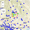
Map showing the initial alert location (red “+” on green symbol), the four stations that reported the initial alert (green circles), and the USGS network location (yellow circle). Red circle is the S-shaking front at alert time. White circles are approximate S-shaking times at 15 second intervals away from the ANSS epicenter. Blue triangles are seismic stations.
Sources/Usage
Public Domain.