
Shenandoah River Watershed Accumulated Wastewater Ratio Mapper

Detailed Description
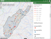
Screenshot of the Shenandoah River Watershed Accumulated Wastewater Ratio Mapper—a web-based mapping application. The mapping application provides a tool to accumulated percent of wastewater at designated river segments (color coded stream segments), wastewater and industrial treatment plant discharges (red and green circles respectively), and U.S. Geological Survey stream gaging stations (black triangles). The accumulated percent of wastewater was derived through refinements to the existing national scale “De facto Reuse Incidence in our Nation’s Consumable Supply” (DRINCS) model.
Sources/Usage
Public Domain.
Related

USGS Chesapeake Bay Highlights for 2019
The U.S. Geological Survey (USGS) works with Federal, State, and academic science partners to conduct monitoring and research in the Chesapeake Bay ecosystem, the Nation’s largest estuary, and other critical ecosystems across the country. The USGS interacts thorough the Chesapeake Bay Program (CBP) to apply science-based decision making for restoration and conservation efforts.

Refined Model Provides a Screening Tool to Understand Exposure to Contaminants from Incidental Wastewater Reuse
Refinement of the existing national-scale “de facto reuse incidence in our nation’s consumable supply” (DRINCS) model, complemented by field measurements, provides a screening tool to understand human and wildlife exposure to toxicants and pathogens associated with the incidental reuse of treated wastewater in the Shenandoah River watershed. The model results can be accessed in a companion web...
Related
USGS Chesapeake Bay Highlights for 2019
The U.S. Geological Survey (USGS) works with Federal, State, and academic science partners to conduct monitoring and research in the Chesapeake Bay ecosystem, the Nation’s largest estuary, and other critical ecosystems across the country. The USGS interacts thorough the Chesapeake Bay Program (CBP) to apply science-based decision making for restoration and conservation efforts.
Refined Model Provides a Screening Tool to Understand Exposure to Contaminants from Incidental Wastewater Reuse
Refinement of the existing national-scale “de facto reuse incidence in our nation’s consumable supply” (DRINCS) model, complemented by field measurements, provides a screening tool to understand human and wildlife exposure to toxicants and pathogens associated with the incidental reuse of treated wastewater in the Shenandoah River watershed. The model results can be accessed in a companion web...