
Side Scan Sonar

Detailed Description
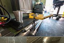
A view of the Klein side scan sonar instrument.
Side scan sonar is a type of technology used to interpret seabed features, material, and textures from acoustic backscatter response intensity. In this application the instrument (towfish) is towed by a cable aft of the vessel. Once activated, a fan- shaped acoustic pulse is repeatedly emitted downward to the seafloor, perpendicular to a vessel's navigation track, collecting a series of swaths stitched together to create a sonogram, or seafloor image. The towfish can be operated with a range of frequencies; lower frequencies are recorded at a lower resolution but increasing swath range, and higher frequencies record with high resolution at the cost of swath range. High-intensity returns are indications of hard or dense surface material, such as rock or hard-packed sand, whereas low-intensity returns may infer silt or organic material. Intensity images are used in conjunction with physical "grab" samples or cores for the purposed of ground truthing the side scan mosaic.
The USGS returned from a seafloor data mapping mission offshore of the Delmarva Peninsula (Ocean City, MD) on July 25th, 2014. The data collected is foundational to our continued understanding of coastal change, vulnerabilities, and making our coastal communities more resilient to coastal hazards and climate change.
Sources/Usage
Public Domain.