
Simulated Earthquake Early Warning for M6.9 Loma Prieta, CA Earthquake

Detailed Description
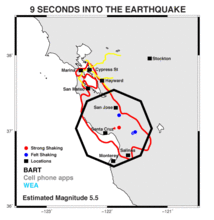
Nine seconds into the earthquake, the current estimated magnitude is 5.5 and the first alert is received by automated systems within the black polygon including the southernmost BART stations. Cell phone apps and WEA alerts have likely not arrived yet at this time. The epicenter is shown by the red star. Blue-filled circles denote locations where shaking was already felt at this time (MMI IV+) and red-filled circles denote where shaking is already Very Strong (MMI VII+). Black squares denote the cities of Santa Cruz, Monterey, Salinas, San Mateo, Hayward, Stockton, the Marina District, and the Nimitz Freeway in Oakland all of which eventually received strong shaking or worse. The red contour denotes the MMI VII region from the USGS Shakemap. The yellow lines denote the BART tracks.
Sources/Usage
Public Domain.
Related

What if the ShakeAlert Earthquake Early Warning System Had Been Operating During the M6.9 1989 Loma Prieta Earthquake?
Related