
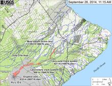
Small-scale map of June 27th flow in Kīlauea's ERZ

Detailed Description
This small-scale map shows the June 27th flow in Kīlauea's East Rift Zone in relation to lower Puna. The area of the flow on September 24, 2014, at 10:45 AM is shown in pink, while widening and advancement of the flow as mapped on September 26 at 11:15 AM is shown in red. The distal tip of the flow was inactive, but small breakouts were scattered across the surface of the flow upslope from the stalled front. The most substantial breakouts were on top of a pad of lava within the crack system about 5 km (3 miles) back from the stalled front, and midway along the length of the flow just upslope from where lava first entered the crack system.
The blue lines show down-slope paths calculated from a 1983 digital elevation model (DEM). For an explanation of down-slope path calculations, see: http://pubs.usgs.gov/of/2007/1264/. Down-slope path analysis is based on the assumption that the DEM perfectly represents the earth's surface. DEMs, however, are not perfect, so the blue lines on this map indicate approximate flow path directions. All older Pu‘u ‘Ō‘ō lava flows (1983-2014) are shown in gray; the yellow line marks the lava tube.
Sources/Usage
Public Domain.