
Small-scale map of Kīlauea's ERZ flow field

Detailed Description
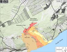
Map showing the Kahauale‘a 2 flow (pink) in relation to the eastern part of the Island of Hawai‘i as of June 17, 2014. Red stars mark the fronts of the active breakouts—the most distant was 7.0 km (4.3 miles) straight-line distance northeast of Pu‘u ‘Ō‘ō. Older lava flows are distinguished by color: episodes 1-48b flows (1983-1986) are shown in gray; episodes 48c-49 flows (1986-1992) are pale yellow; episodes 50-55 flows (1992-2007) are tan; episodes 58-60 flows (2007-2011) are pale orange, and episode 61 flows (2011-2013) are reddish orange. The active lava tube is shown with a yellow line (dashed where its position is poorly known).
Sources/Usage
Public Domain.